")


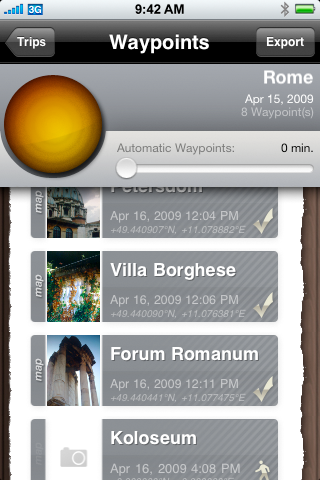
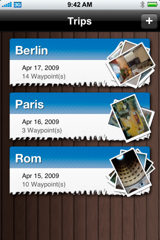
PhotoTrip makes geotagging available for every camera that stores a timestamp along with it's photographs. Just create a Trip in the application and set the auto waypoint interval. PhotoTrip will periodically record your current location.
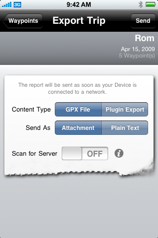
When you are finished, you can send the recorded data in the open GPX file-format to you computer and use any tool you like to add the GPS geo information to your photographs or simply view your trip in Google Earth.
If you use Aperture to manage your photos, you can use our Aperture Plugin to write the location informations stored by PhotoTrip to your photos.
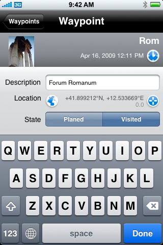
PhotoTrip allows you to add a short description for each Waypoint that you record. You can even add a photograph that helps you remember what was special about a particular location.
If you do not need automatic waypoint recording, you can manually add waypoints to a particular trip whenever you like. PhotoTrip even let's you mark Waypoints as "planed". That way you can prepare all the sites you want to visit in advance. When on the location of a planed waypoint you can add a photograph, the gps information and the current date.
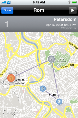
Beginning with Version 1.5 display a recorded route directly on a map within the app. The map also allows you to provide a location for a waypoint without using the location service of the iPhone (prefect for planing trips).
 Another cool new feature in version 1.5 is Direct to Mac. Combined with our Mac tools it is really simple to transfer your waypoints from the iPhone to your Mac. Simply start Geotagger or any of our Aperture Plugins and the rest is almost automatic.
Features
- Automatically or manually create waypoints
- Waypoints store GPS information (longitude, latitude and altitude; only on devices that provide CoreLocation)
- Attach a photograph to each waypoint (only on devices with a camera)
- Export Tracklog as GPX-file via eMail
- Open Safari to show the location of a waypoint on a Google Map.
- Use our Aperture Plugin or any other tool that can read GPX-files to geotag photographs taken with an external camera (perfect for iPhotos Places feature) or create maps for your trips (for example with Google Earth)
- Plan trips in advance (what sites do you plan to visit) and fill in the location information as you arrive on location
- Send eMails as plain text or with file attachments (the later requires you to configure a SMTP-Server in PhotoTrip)
- No Internet connection required to record your waypoints
- Display recorded routes directly on a map in the application
- Set the position of a waypoint with out GPS (using a map)
- Direct To Mac for convenient transfer of your waypoint data to your Mac
THIS SOFTWARE IS PROVIDED BY THE COPYRIGHT HOLDERS AND CONTRIBUTORS "AS IS" AND ANY EXPRESS OR IMPLIED WARRANTIES, INCLUDING, BUT NOT LIMITED TO, THE IMPLIED WARRANTIES OF MERCHANTABILITY AND FITNESS FOR A PARTICULAR PURPOSE ARE DISCLAIMED. IN NO EVENT SHALL THE COPYRIGHT OWNER OR CONTRIBUTORS BE LIABLE FOR ANY DIRECT, INDIRECT, INCIDENTAL, SPECIAL, EXEMPLARY, OR CONSEQUENTIAL DAMAGES (INCLUDING, BUT NOT LIMITED TO, PROCUREMENT OF SUBSTITUTE GOODS OR SERVICES; LOSS OF USE, DATA, OR PROFITS; OR BUSINESS INTERRUPTION) HOWEVER CAUSED AND ON ANY THEORY OF LIABILITY, WHETHER IN CONTRACT, STRICT LIABILITY, OR TORT (INCLUDING NEGLIGENCE OR OTHERWISE) ARISING IN ANY WAY OUT OF THE USE OF THIS SOFTWARE, EVEN IF ADVISED OF THE POSSIBILITY OF SUCH DAMAGE.
iPhone is a trademark of Apple Inc.